Military Control Service
Military Control Area of Responsibility
In vFIR Warszawa, military air traffic control services are provided at the airports of Poznań-Krzesiny (EPKS) and Dęblin (EPDE).
The controlled airspaces of military air traffic services (MCTR and MTMA) are classified as Class D airspace.
GAT traffic is handled in accordance with the provisions outlined in the Aerodrome Control and Approach Control sections.
OAT OPERATIONS MAY ONLY BE CONDUCTED BY APPROVED vSOA
Top-down service
In the absence of military ATC services, MCTR and MTMA are downgraded to uncontrolled airspace (Class G). MCTR and MTMA are not provided with top-down service by higher ATC positions.
Departure and arrival at a military airport
Aircraft conducting GAT flights should use the appropriate entry/exit fixespublished in the SID/STAR procedures. If these are unavailable, any fix within a 50 NM radius from the ARP may be used. The selected exit fix should allow a seamless transition into the flight route without additional maneuvers.
When using FRA, the entry/exit point should be any FRA INTERMEDIATE point within a 50 NM radius from the ARP.
Aircraft conducting OAT flights should use OAT coordination points specific to the respective military airport as entry/exit points. The list of OAT coordination points is available in AIP MIL ENR 2.3.0.
Minima for VFR flight within Military Controlled Airspace
The minimum meteorological conditions required for conducting VFR flights in military controlled airspace comply with the conditions for civilian airspace, except for VFR flights in MTMA and special VFR flights in MCTR.
VFR flights in MTMA
The minimum meteorological conditions for conducting VFR flights in MTMA are:
- during day:
| Flight level | Visibility | Horizontal distance from clouds | Vertical distance from clouds | Visual contact with terrain |
|---|---|---|---|---|
| above FL100 | 8 km | 300 m/1000 ft | 1500 m | not required |
| below FL100 above 3000 ft | 5 km | 300 m/1000 ft | 1500 m | not required |
| below 3000 ft | 5 km | N/A | N/A | required |
- during night
| Flight level | Visibility | Horizontal distance from clouds | Vertical distance from clouds | Clouds ceiling |
|---|---|---|---|---|
| above FL100 | 8 km | 300 m/1000 ft | 1500 m | 1500 ft |
| below FL100 above 3000 ft | 5 km | 300 m/1000 ft | 1500 m | 1500 ft |
| below 3000 ft | 5 km | N/A | N/A | 1500 ft |
VFR flights in MCTR
The minimum meteorological conditions for conducting VFR flights in MCTR are:
| Time of day | Aircraft type | Aircraft ownership | Visibility | Clouds ceiling |
|---|---|---|---|---|
| day | airplane | civil | 1500 m | 180 m/600 ft |
| day | airplane | military | 2000 m | 150 m/500 ft |
| day | helicopter | civil | 800 m | 180 m/600 ft |
| day | helicopter | military | 1500 m | 150 m/500 ft |
| night | helicopter | military | 3000 m | 300 m/1000 ft |
Aerodrome overhead operations
Due to the specifics of military traffic, the following types of overhead aerodrome operations are distinguished:
- standard pattern – a classic aerodrome traffic circuit,
- closed pattern,
- overhead pattern.
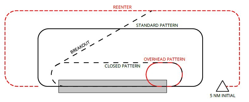
The intention to perform any of the aforementioned maneuvers signifies a transition to VFR flight.
Closed pattern
The Closed pattern is a variant of the aerodrome traffic circuit consisting of two 180° turns. The aircraft should establish itself on final no further than 2 NM from the threshold of the runway in use.
If necessary, the TWR controller may issue a BREAKOUT instruction. The pilot climbs 500 ft above the Overhead pattern altitude and proceeds either toward a VFR point or joins the OUTSIDE DOWNWIND position (parallel to the downwind leg, outside the aerodrome traffic circuit, depending on instructions) and awaits further clearance.
Overhead pattern
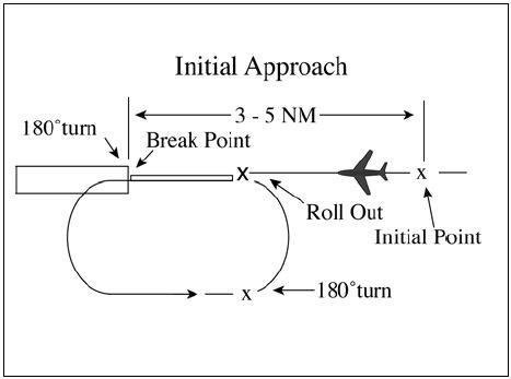
The Overhead pattern is designed for landing both single aircraft and formations. It allows for a reduced time required to land an entire formation.
The pilot initiates the procedure with the phrase: “Request initial” or “Request overhead pattern.”
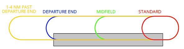
The overhead pattern procedure begins at the INITIAL point, located 3-5 NM from the threshold of the runway in use. At this position, the pilot should be informed of the type and direction of the break to be performed:
- over the numbers / standard break,
- midfield,
- departure end,
- 1-4 NM past departure end.
If the overhead pattern cannot be executed or for separation from other air traffic, the TWR controller may issue a REENTER instruction. In this case, the pilot exits the circuit and joins the OUTSIDE DOWNWIND position to return to the INITIAL point.
vFIR Warszawa Military Aerodromes
EPDE - Dęblin
Aerodrome geographical data
| Full name | ARP | Localization | Elevation |
|---|---|---|---|
| Deblin Military Airport | 51°33'04''N 021°53'31''E | 1.2 NM from Deblin city | 394 ft |
Aerodrome control service positions
| Position | Frequency [MHz] | Callsign |
|---|---|---|
| EPDE_TWR | 122.750 | Dęblin Tower |
| EPDE_APP | 128.250 | Dęblin Approach |
Runways
| Designator | Mag. heading | Dimensions | Equipment |
|---|---|---|---|
| 12 | 115° | 2500 x 60 | - |
| 30 | 295° | 2500 x 60 | ILS CAT I |
Ground movement procedures
Taxi instructions for landing aircraft are issued not to a specific stand but to the apron.
Entry to and exit from the maneuvering area for aircraft taxiing from the aeroclub area is possible via Apron C or Taxiway A (A/D intersection). TWR controller clearance is required to enter the maneuvering area.
Departures and arrivals of helicopters can be performed from intersection of taxiway A and D.
VFR traffic
VFR flights transiting through MCTR Dęblin or performing aerodrome traffic circuits should maintain a constant cruising altitude of 1500 ft.
During periods of high traffic density, a VFR aircraft may be instructed to hold over the following points if necessary:
- hold north of point NOVEMBER.
- hold south of point SIERRA.
MCTR Dęblin is Class D airspace.
Overhead pattern procedure
Minimum conditions: Cloud ceiling 2500 ft AGL, visibility 5 km.
The INITIAL point for EPDE is located 3 NM from the threshold of the runway in use at an altitude of 2400 ft AMSL (2000 ft AGL).
As a standard, all formation breakup maneuvers should be performed northward.
Closed pattern procedure
Minimum conditions: Cloud ceiling 2000 ft AGL, visibility 5 km.
The CLOSED PATTERN may be performed no higher than 1900 ft AMSL (1500 ft AGL).
As a standard, all maneuvers in the CLOSED PATTERN should be performed northward.
EPKS - Poznań - Krzesiny
Aerodrome geographical data
| Full name | ARP | Localization | Elevation |
|---|---|---|---|
| Poznań-Krzesiny Military Airport | 52°19'55''N 016°58'00''E | 5.4 NM from Poznań city | 276 ft |
Aerodrome control service positions
| Position | Frequency [MHz] | Callsign |
|---|---|---|
| EPKS_TWR | 121.025 | Krzesiny Tower |
| EPKS_P_APP | 120.750 | Krzesiny Precision |
Runways
| Designator | Mag. heading | Dimensions | Equipment |
|---|---|---|---|
| 11 | 114° | 2500 x 60 | - |
| 29 | 294° | 2500 x 60 | ILS CAT I |
Ground movement procedures
Taxi instructions for landing aircraft are issued not to a specific stand but to the apron.
Departures and arrivals of helicopters can be performed on helipad between taxiways A and F.
VFR traffic
VFR flights transiting through MCTR Krzesiny or performing aerodrome traffic circuits should maintain a constant cruising altitude of 1500 ft.
Aircraft departing from Żerniki airstrip, which is located within MCTR, are required to file a flight plan and obtain clearance from the TWR Krzesiny controller before departure.
Unless otherwise specified in the clearance, the aircraft shall proceed to point ROMEO after takeoff from Żerniki.
MCTR Krzesiny is Class D airspace.
Overhead pattern procedure
Minimum conditions: Cloud ceiling 2500 ft AGL, visibility 5 km.
The INITIAL point for EPKS is located 3-5 NM from the threshold of the runway in use at an altitude of 1800 ft AMSL (1500 ft AGL).
As a standard, all formation breakup maneuvers should be performed southward.